
By: Jacquelyn Grace
In August of 2017, Hurricane Harvey hit the Texas coast, causing widespread catastrophic flooding. Over four days, many areas received over 40 inches of rain, resulting in the deaths of 103 Texans and leaving 30,000 people displaced and 336,000 people without electricity. But the hurricane and associated flooding impacted more than just human lives and welfare. One of the goals of our research program at Texas A&M University is to understand how Harvey and other hurricanes and natural disasters impact bird communities along the Gulf of Mexico.
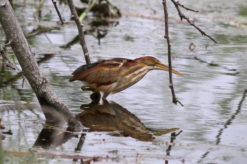
Photo by Michael McCloy
First, we have to ask: what do birds do during a hurricane? When a hurricane hits, humans will either fortify their homes and hunker down, or evacuate the area. We know that birds essentially do the same things: either stay in place, or leave ahead of the storm. Either of these choices can result in increased mortality of adults or young. Staying in place can result in death through direct storm impacts or destruction of foraging habitat and food sources. Leaving can result in death through the high energetic cost of flight during inclement weather, and unknown foraging potential in distant habitat. There’s no good option! In 2017, Hurricane Harvey hit at the tail end of the breeding season in Texas, when many fledglings were still learning the ways of the world. These fledglings would have been especially vulnerable to storm impacts due to their low energetic reserves and their relatively poor flight and foraging skills. If parents opted to leave, any chicks left in the nest would almost certainly have died.
If a bird does survive a hurricane, either by leaving or staying, it then has to deal with severely altered habitat after a major storm. The extensive flooding caused by Hurricane Harvey changed stream beds, killed or changed vegetation, increased salinity of freshwater sources through storm surge, and caused build-up of vegetative and anthropogenic debris. We know relatively little about how individual birds and bird communities respond to these direct and indirect effects of natural disasters. We are particularly interested in understanding the resilience of avian communities to natural disasters. How quickly can bird communities rebound from these events?
Resilience capacity is a fundamental aspect of ecological community dynamics, and is critical for planning conservation areas for wildlife populations and sustaining the ecosystem services they provide to human communities, such as safe and sufficient food and water. However, measuring resilience to extreme weather events is difficult because data must be collected before an event that is unpredictable in both location and time. We are very lucky that ongoing monitoring projects along the Gulf of Mexico solve this problem for us and provide invaluable baseline data for bird community diversity and richness, and individual physiology. Nation-wide standardized monitoring projects such as the Monitoring Avian Productivity and Survivorship Program (MAPS), and Breeding Bird Survey (BBS), and smaller local long-term monitoring projects including the Texas Colonial Waterbird Census, are critical to establish what is “normal” for birds on the Gulf Coast, so that we can then uncover what is abnormal following extreme weather events.
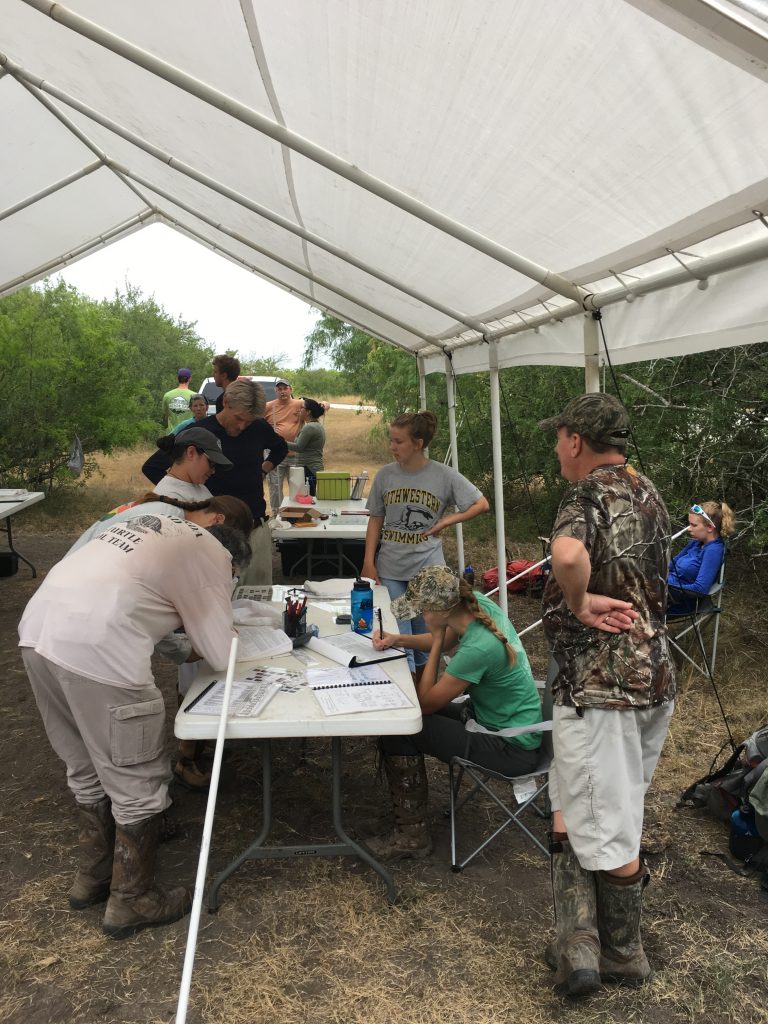
Photo by Michael McCloy
Led by one of my graduate students, Michael McCloy, our project looks at the impact of hurricanes on avian communities at both the regional and the local scale. At the regional scale, we utilize large existing avian datasets including eBird and Breeding Bird Survey. At the local scale, we are using historic avian population and productivity data for the Welder Wildlife Refuge (WWFR) through an ongoing MAPS banding program, along with intensive field monitoring through distance-based point counts and deployment of Autonomous Recording Units. The WWFR is in the Coastal Bend region of the Texas Gulf Coast; a region dominated historically by Texas Coastal Prairie and currently by rangeland and agriculture. It is located less than 20km from the communities of Bayside and Rockport that were most heavily damaged by Hurricane Harvey. WWFR and its natural wetlands were directly along the storm path and lie along the Aransas River, providing ecosystem services to these impacted communities, and a natural gradient of impact following the storm. The local economy relies substantially on conservation for recreational pursuits, including birding and hunting – valued at more than $5,286 per hectare/year (USD2017). The intensity of hurricanes in this area is expected to increase in the future. Thus, data on resilience is essential to plan recovery of ecosystem services for impacted communities along the coast for this event and in preparation for future events.
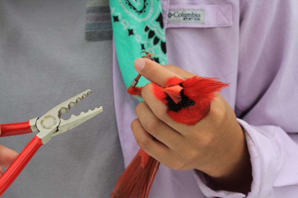
Photo by Michael McCloy
We are currently in our third year of conducting post-Harvey monitoring and field surveys. Unfortunately, the COVID-19 pandemic has temporarily shut down our primary field sites, but we are hoping to continue data collection in mid-summer. Initial analyses suggest that impacts of Hurricane Harvey are species-, and perhaps guild-specific. For instance, Northern Cardinals show a decline in body condition in the year following the hurricane, while White-eyed Vireos do not. Our ultimate goal is to evaluate both immediate and long-term effects of hurricanes on individual body condition, species productivity, and community structure. to enable informed management of wildlife areas following these severe weather events.